First of all, there will be no more tests before next week's semester exam. I hope you are not too disappointed.
Since I will not be in class today, this is a golden opportunity for you to review for the semester exam. As I have been saying, IF you study for this test, you WILL get a better grade. So spend the class going over this material, making flash cards (Quizlet is your friend), adding notes to your blog, and doing whatever else you need to be ready for next week. And I hope to see you tomorrow (Honorz) or Monday (HG 101) !
What is Human Geography?
Human Geography is the branch of Geography that deals with the study of people and their communities, cultures, economies, and interactions with the environment by studying their relations with and across space and place.
Human geography focuses on:
How people make places
How we organize space and society
How we interact with each other
How we make sense of ourselves and others.

Human Geography World Regions

A map is a scale model of the real world, made small enough to work with on a desk or computer. It can be a hasty here’s-how to-get-to-the-party sketch, an elaborate work of art, or a precise computer-generated product. A map serves two purposes: It is a tool for storing reference material and a tool for communicating geographic information.As a reference tool. A map helps us to find the shortest route between two places and to avoid getting lost along the way. We consult maps to learn where in the world something is found, especially in relation to a place we know, such as a town, body of water, or highway. The maps in an atlas or a road map are especially useful for this purpose.
As a communications tool, a map is often the best means for depicting the distribution of human activities or physical features, as well as for thinking about reasons underlying a certain characteristic or feature. In this sense, we use maps to tell stories about the world.
Reference and Thematic maps are the two tools that geographers use to map the world. Reference maps are generally separated into two categories, physical and political. Physical reference maps show us physical features of a place and political reference maps show us boundaries, major cities, and capitals. Where there will be certain similarities, the major distinction between reference maps and thematic maps is that the thematic maps will tell us "stories" about the distribution of certain geographic phenomena around the world.
All of us have images of the world that we have developed through a variety of processes. These processes are usually a mix of factual data, incomplete information, and personal bias or subconscious prejudices. A mental map is a mental map is a person's point-of-view perception of their area of interaction, most commonly called your activity space. This can also include areas that we have never been to but have seen on television or read about.
The Geographic grid is a system of imaginary arcs drawn in a grid pattern on Earth’s surface.
–Meridians are arcs drawn between the North and South poles. Each is numbered, according to a system known as longitude.
Values range from 0º (prime meridian) to 180º (international date line) east or west longitude.
–Parallels are arcs drawn parallel to the equator and at right angles to meridians. Each is numbered, according to a system known as latitude.
Values range from 0º (equator) to 90º north or south.
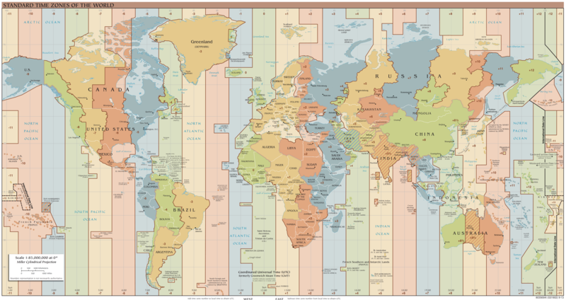
A time zone is a region of the globe that observes a uniform standard time for legal, commercial, and social purposes.
MAIN POINTS
Earth as a sphere is divided into 360º of longitude.
–Divide 360º by 24 time zones (one for each hour of day) equals 15º.
There are actually more than 24 time zones, due to weirdness concerning the International Date Line and widely scattered islands in the south Pacific Ocean.
Each 15º band of longitude is assigned to a standard time zone.
Greenwich Mean Time (GMT), also called UTC:
- is located at the prime meridian (0º longitude).
- passes through Royal Observatory at Greenwich, England
- is the master reference time for all points on Earth.
The Global Positioning System (GPS) is a space-based radionavigation system owned by the United States government and operated by the United States Air Force. It is a global navigation satellite system that provides geolocation and time information to a GPS receivers anywhere on or near the Earth where there is an unobstructed line of sight to four or more GPS satellites.
Why Is Each Point on Earth Unique?
Each place on Earth is in some respects unique and in other ways similar to other places. The interplay between the uniqueness of each place and the similarities among places lies at the heart of geographic questioning about why things are found where they are.Two basic concepts help geographers to explain why every point on Earth is in some ways unique—place and region. The difference between the two concepts is partly a matter of scale: A place is a point, whereas a region is an area.
Place
Geographers think about where particular places and regions are located and the combination of features that make each place and region on Earth distinct. Geographers describe a feature’s place on Earth by identifying its location, the position that something occupies on Earth’s surface, and in doing so consider four ways to identify location: place name, site, situation, and mathematical location.
A toponym is the name given to a place on Earth.
Site
The second way that geographers describe the location of a place is by site, which is the physical character of a place. Important site characteristics include climate, water sources, topography, soil, vegetation, latitude, and elevation. The combination of physical features gives each place a distinctive character.
Situation
Situation is the location of a place relative to other places. Situation is a valuable way to indicate location, for two reasons— finding an unfamiliar place and understanding its importance. First, situation helps us find an unfamiliar place by comparing its location with a familiar one. We give directions to people by referring to the situation of a place: “It’s down past the courthouse, on Locust Street, after the third traffic light, beside the yellow-brick bank.” We identify important buildings, streets, and other landmarks to direct people to the desired location. Second, situation helps us understand the importance of a location. Many locations are important because they are accessible to other places.
Region
An area of Earth defined by one or more distinctive characteristics is a region.
Cultural Landscape
A region derives its unified character through the cultural landscape—a combination of cultural features such as language and religion, economic features such as agriculture and industry, and physical features such as climate and vegetation.
The designation of “region” can be applied to any area larger than a point and smaller than the entire planet. Geographers most often apply the concept at one of two scales: Several neighboring countries that share important features, such as those in Latin America; or the many localities within a country, such as those in southern California.
In thinking about why each region on Earth is distinctive, geographers refer to culture, which is the body of customary beliefs, material traits, and social forms that together constitute the distinct tradition of a group of people.
The origin of the word culture is the Latin cultus, which means “to care for.”Culture is a complex concept because “to care for” something has two very different meanings:
To care about—to adore or worship something, as in the modern word cult.
To take care of—to nurse or look after something, as in the modern word cultivate.
Globalization
Scale is an increasingly important concept in geography because of globalization, which is a force or process that involves the entire world and results in making something worldwide in scope. Globalization means that the scale of the world is shrinking—not literally in size, of course, but in the ability of a person, object, or idea to interact with a person, object, or idea in another place.
Connections Between Places
Diffusion is the process by which a characteristic spreads across space from one place to another over time.
A resource is a substance in the environment that is useful to people, economically and technologically feasible to access, and socially acceptable to use. A substance is merely part of nature until a society has a use for it. Food, water, minerals, soil, plants, and animals are examples of resources.
Earth's resources are divided between those that are renewable and those that are not :A renewable resource is produced in nature more rapidly than it is consumed by humans. A nonrenewable resource is produced in nature more slowly than it is consumed by humans.Geographers observe two major misuses of resources: 1) Humans deplete nonrenewable resources, such as petroleum, natural gas, and coal. 2.) Humans destroy otherwise renewable resources through pollution of air, water, and soil. The use of Earth's renewable and nonrenewable natural resources in ways that ensure resource availability in the future is sustainability. Efforts to recycle metals, paper, and plastic, develop less polluting industrial processes, and protect farmland from suburban sprawl are all examples of practices that contribute to a more sustainable future.
Population
The study of population is critically important for three reasons:More people are alive at this time— 7.4 billion—than at any point in Earth’s long history.
The world’s population increased at a faster rate during the second half of the twentieth century than ever before in history.
Virtually all global population growth is concentrated in the developing world.
Demography is a social science which entails the statistical study of human populations.
How do we measure population change and what does this tell us about a place?
Rate of Natural Increase (RNI;NIR): a statistic that expressed a country or region’s annual growth rate; expressed as a percentage. Crude Birth-Crude Death=RNI.
Total Fertility Rate: a synthetic rate that expresses the fertility of a country or region; commonly understood as the average number of children a woman would give birth to during her reproductive years.
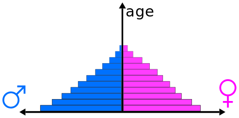
Population Pyramids: The visual representation of a nation’s population representing age and gender. This gives us a quick synopsis as to what is happening to a nation’s population (i.e. is it growing, stable, or shrinking). Rapid Growth, Slow/Stable Growth, Negative/Declining Growth.
Life Expectancy: the average number of years a person is expected to live from birth; influenced by health services, nutrition, and sanitation; used as an indicator of social development. This is our go to indicator that tells us how health a population set is.
The Demographic Transition: a conceptual model that tracks changes in birth and death rates for a country or region over time. 4 stages moving from pre-industrial, early industrial, late industrial, and post industrial.
Infant mortality rate compares the number of deaths of infants under one year old in a given year per 1,000 live births in the same year. This rate is often used as an indicator of the level of health in a country.
A population pyramid, also called an age pyramid or age picture is a graphical illustration that shows the distribution of various age groups in a population (typically that of a country or region of the world), which forms the shape of a pyramid when the population is growing. This tool can be used to visualize gender and age composition of a particular population.
Demographic Transition (DT) refers to the transition from high birth and death rates to lower birth and death rates as a country or region develops from a pre-industrial to an industrialized economic system.

More Developed Countries v Developing Countries

What is Migration?
Emigrant or Immigrant?
When a person leaves his country to take up permanent residence in another country, he/she becomes an emigrant and an immigrant.
He/she is an emigrant upon leaving his homeland and an immigrant upon arriving at his/her destination.
Reasons for Migrating
• Most people migrate for economic reasons.
• Cultural and environmental factors also induce migration, although not as frequently as economic factors.
People decide to migrate because of push factors and pull factors. A push factor induces people to move out of their present location, whereas a pull factor induces people to move into a new location.
There will also be questions on the exam from our unit on Excellence. Please refer to your notes and my blogs regarding Elbert Hubbard, the ancient Greeks, Socrates, and democracy.
If you have read this far, I am impressed! Obviously you are serious about studying for your Human Geo exam, which bodes well for you.
Finally, here is the essay question you will be required to answer. I will post your options for the second essay question soon.
You are given two population pyramids which represent two countries at different stages of the
demographic transition and economic development.
A. Explain the demographic characteristics of each country above with respect to the demographic transition
model.
B. Describe potential issues both countries could face in the future if their population pyramids remain the same.
C. Discuss possible solutions to each country’s population concerns.


No comments:
Post a Comment